Date: Thursday 12 June 1980
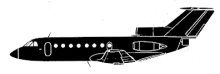
Aircraft Type: Yakovlev Yak-40
Owner/operator: Aeroflot / Tajikistan
Registration Number: CCCP-87689
Location: 44 km NW of Dushanbe –
ÿ Tajikistan
Phase of Flight: Approach
Status: Destroyed, written off
Casualties: Fatalities: 29 / Occupants: 29
Component Affected: Radio compassRadio compass