Incident Overview

Date: Saturday 19 July 2003
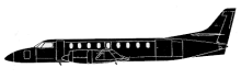
Aircraft Type: Swearingen SA226-TC Metro II
Owner/operator: Ryan Blake Air Charter
Registration Number: ZS-OYI
Location: Mount Kenya – ÿ Kenya
Phase of Flight: En route
Status: Destroyed, written off
Casualties: Fatalities: 14 / Occupants: 14
Component Affected: Radar systemRadar system
Category: Accident
A Swearingen Metro plane crashed into the eastern slope of Point Lenana, resulting in significant damage and debris. The crash occurred at an altitude of approximately 450 feet below the snow-capped peak, scattering debris across adjacent valleys. The probable cause was pilot error ? inadequate situational awareness regarding terrain proximity, leading to a controlled flight into terrain. Contributing factors included unfamiliar airspace, inadequate flight planning, poor communication, radar controller failure, and lack of radar system warnings. The incident highlights a systemic failure across multiple aviation systems.A Swearingen Metro plane crashed into the eastern slope of Point Lenana, resulting in significant damage and debris. The crash occurred at an altitude of approximately 450 feet below the snow-capped peak, scattering debris across adjacent valleys. The probable cause was pilot error ? inadequate situational awareness regarding terrain proximity, leading to a controlled flight into terrain. Contributing factors included unfamiliar airspace, inadequate flight planning, poor communication, radar controller failure, and lack of radar system warnings. The incident highlights a systemic failure across multiple aviation systems.

Description

The Swearingen Metro plane, carrying 12 American tourists and two South African crew members, departed Nairobi-Wilson Airport at 15:58 for a flight to the Samburu national park. The flight plan was to allow the crew to fly round Mount Kenya before landing at a private airstrip in the game park. The airplane crashed into the eastern slope of Point Lenana (16,450 feet), which is the third highest peak of Mount Kenya. The crash site was located approx. 450 feet below the snow-capped top. Debris scattered into the adjacent valleys of the peak, and then burnt throughout the night. Probable cause: The pilots’ failure to maintain horizontal and vertical situational awareness of the aircraft’s proximity to the surrounding terrain, resulting in inadequate clearance, and controlled flight into terrain. Contributing factors: – Unfamiliarity with the airspace and the route in particular and the existence of high ground on the planned flight route. – Inadequate flight planning by the pilots and distraction of their attention when they were instructed to contact Nanyuki. – Poor pilot briefing by the Wilson ATC briefing office. – Poor communication between the air traffic control units. – Failure of the radar controller to advise the pilot of termination of radar service. – Lack of a radar system minimum safe altitude warning to the radar controller – Poor civil military coordination during transit through the military airspace.

Primary Cause

Pilot error ? inadequate situational awareness regarding terrain proximity leading to a controlled flight into terrain.Pilot error ? inadequate situational awareness regarding terrain proximity leading to a controlled flight into terrain.

Share on:

Leave a Reply

Your email address will not be published. Required fields are marked *