Incident Overview

Date: Wednesday 6 April 2016
Aircraft Type: Raytheon U-125 (Hawker 800)
Owner/operator: Japan Air Self-Defense Force – JASDF
Registration Number: 49-3043
Location: 10 km N of Kanoya Air Base – ÿ Japan
Phase of Flight: En route
Status: Destroyed, written off
Casualties: Fatalities: 6 / Occupants: 6
Component Affected: Aircraft (U-125)Aircraft (U-125)
Category: Accident
On April 7th, a British Aerospace U-125 aircraft, attached to the Japan Air Self-Defence Force’s Hiko Tenkentai Flight Check Squadron, crashed near Kanoya Air Base, Japan. The aircraft departed Iruma at 08:49 for a check flight to Kanoya, and landed at Kanoya at 12:06 after refueling. Following the check, the plane took off at 13:15 and performed the remaining checks of the JAT TACAN. At 14:31, the aircraft initiated an ‘alignment orbit check’ over runway 08R, during which it lost radar contact after an anti-clockwise 6nm arc with an altitude of 3000 feet. The wreckage was discovered on Ontake peak of Mt. Takakuma, approximately 1182 meters (3875 feet) above sea level, on April 7th. The pilot, acting as Pilot Not Flying, and the Flight Officer were responsible for the flight. A GPWS warning was issued 12 seconds before the crash, but it was switched off 2 seconds before, without any avoidance maneuvers. The crash was attributed to continued flight until the crash, resulting from a 6nm arc from the JAT TACAN, at an altitude of 3000 feet. Contributing factors included the pilot’s misidentification of heights, visual obscuration, and inadequate response to the GPWS warning.On April 7th, a British Aerospace U-125 aircraft, attached to the Japan Air Self-Defence Force’s Hiko Tenkentai Flight Check Squadron, crashed near Kanoya Air Base, Japan. The aircraft departed Iruma at 08:49 for a check flight to Kanoya, and landed at Kanoya at 12:06 after refueling. Following the check, the plane took off at 13:15 and performed the remaining checks of the JAT TACAN. At 14:31, the aircraft initiated an ‘alignment orbit check’ over runway 08R, during which it lost radar contact after an anti-clockwise 6nm arc with an altitude of 3000 feet. The wreckage was discovered on Ontake peak of Mt. Takakuma, approximately 1182 meters (3875 feet) above sea level, on April 7th. The pilot, acting as Pilot Not Flying, and the Flight Officer were responsible for the flight. A GPWS warning was issued 12 seconds before the crash, but it was switched off 2 seconds before, without any avoidance maneuvers. The crash was attributed to continued flight until the crash, resulting from a 6nm arc from the JAT TACAN, at an altitude of 3000 feet. Contributing factors included the pilot’s misidentification of heights, visual obscuration, and inadequate response to the GPWS warning.

Description

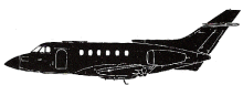
A British Aerospace U-125 of the Japan Air Self-Defence Force was destroyed in an accident in mountainous terrain near Kanoya Air Base, Japan with 6 persons on board. The aircraft was attached to the Hiko Tenkentai Flight Check Squadron based at Iruma Air Base. The accident plane took off from Iruma at 08:49 for a check flight to Kanoya Air Base, and after planned check at Kanoya in the morning, it landed at Kanoya at 12:06. After refueling, the plane took off at 13:15, and performed the remaining check of the JAT TACAN. At 14:31, the plane began the ‘alignment orbit check’ following a low pass over runway 08R. In this check, the plane lost radar contact while flying an anti-clock-wise 6nm arc with an altitude of 3000 feet after climbing from 2500 feet. The wreckage was found by a search party of Japan Grand Self-Defense Force on 7th April on Ontake peak of Mt. Takakuma, which has an elevation of 1182m (3875 feet). At the time of the accident, the captain acted as Pilot Not Flying and F/O was Pilot Flying. A GPWS warning sounded 12 seconds before the crash, however, the warning was switched off 2 seconds before the crash without any avoidance maneuvers. The cause of the accident was continued flight until the crash on 6nm arc from Kanoya JAT TACAN with an altitude of 3000 feet. The factors of the accident were: PIC’s misidentification on the heights of mountains under the planned flight path, visual obscuration near and/or in the clouds after climbing from 2500 feet to 3000 feet, and no adequate response to the GPWS warning. A contribution factor of insufficient supervision to the flight plan is also identified.

Source of Information

http://headlines.yahoo.co.jp/hl?a=20160406-00000096-jij-soci, http://mainichi.jp/articles/20160407/k00/00e/040/230000chttp://headlines.yahoo.co.jp/hl?a=20160406-00000096-jij-soci, http://mainichi.jp/articles/20160407/k00/00e/040/230000c

Primary Cause

Continued flight until the crash, resulting from a 6nm arc from the JAT TACAN, at an altitude of 3000 feet.Continued flight until the crash, resulting from a 6nm arc from the JAT TACAN, at an altitude of 3000 feet.

Share on:

Leave a Reply

Your email address will not be published. Required fields are marked *