Incident Overview
Description
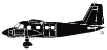
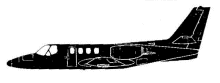
On 23 and 24 September 1970 flight FI 704 from Reykjavik, Iceland to V gar, Faroe Islands, Denmark, was cancelled due to the weather at V gar. On 25 September Fokker F-27 TF-FIL left Reykjavik as flight FI 704 with estimated arrival over the “MY” radio beacon near V gar at 15:52. However, due to fog at V gar, landing was not possible, and after about 45 minutes holding, the flight continued on to Bergen Airport, Norway, and landed there at 18:22. Shortly after landing the captain asked the meteorological service for the forecast for V gar for the following morning. He was informed that there was a possibility that the fog would lift due to increasing wind. The observation from V gar the next day at 06:00 was still fog, but at 06:20 an observation gave a visibility of 10 km with cloud base at 2000 feet and a few clouds at lower altitude. During the next hour the weather improved further, and the captain decided to start. When asking the meteorological service he was told that there was 50% chance that the weather at V gar would last. The expected increase in the wind force had not yet occurred. Take-off was at 08:22 with Bergen as the alternate airport. TF-FIL arrived over Myggenaes NDB at about 10:20. Landing were to take place on runway 13, the approach should therefore be from the west through the Sorvag Fjord. The weather at 10:15 at the airfield was wind 140ø 15 kts., visibility SE 5 km. NW 7 km. rain, clouds 1/8 1000 ft, 7/8 1700 ft , QNH 1006.5. The procedure turn and descent were started, as the weather was above the minima required for landing at the airfield. Descent took place to the SE which is in accordance with one of the procedures used by Icelandair. At one time during the procedure the captain mentioned that he was able to see the ocean from an altitude of 3000 feet. Shortly thereafter VMC below the clouds immediately west of V gar was reported. However, the captain could not see the mouth of the fiord, whereas he very clearly saw Myggenaes. Around this time visibility in the fiord was 10 kms. Likely a rain shower was just at the mouth of the fiord. At first the captain decided to wait for VMC below the clouds, expecting fast improvement of visibility. However, as this improvement did not occur, ascent was started with the intention of holding over the MY radio beacon. At about 10:30 it was reported from the aircraft that it had reached an altitude of 3000 feet and that it would hold for awhile. The aircraft stayed in the holding over MY for about 25 minutes. While holding, the aircraft was kept continuously informed of the weather in the inbound and outbound flight directions to/from V gar. V gar also obtained weather information for possible alternate airports in Iceland and Scotland. At around 10:48 V gar reported 8 km. visibility to the NW and 4-5 km. to the SE, and TF-FIL replied that when visibility to the SE had improved, they would start a new approach procedure. At 10:52 V gar reported that visibility to the SE was 5 km. and TF-FIL acknowledged that they would now turn around to MY and initiate a procedure. At about 10:55 TF-FIL reported: “We are coming over MY inbound descending.” About 1 minute later TF-FIL impacted rising terrain on Myggenaes Island at an altitude about 1500 feet above sea level 4.8 km. from MY. The investigation showed that the weather radar was switched on at the time of the accident, and that the T/R unit had an instability between 315 KHz and 339 KHz. At the same time ADF I and II were tuned to “MY” radio beacon on 337 KHz. The instability of the radar has apparently interfered with the “MY” NDB. The cause of the accident was that FI 701 began a descent through cloud procedure from a starting point other than over “MY” NDB. During this procedure the aircraft hit close to the highest point of Myggenaes at an altitude of about 1500 ft. The reason for starting the procedure from a position other than “MY”, has probably been an interference caused by FI 701’s weather radar, which on the ADF’s has given the crew an erroneous indication that they were passing “MY” NDB.
Primary Cause
Radar interference caused by the FI 701 weather radar, leading to an erroneous indication of passing ‘MY’ NDB.Radar interference caused by the FI 701 weather radar, leading to an erroneous indication of passing ‘MY’ NDB.Share on: