Incident Overview

Date: Sunday 15 November 1964
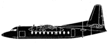
Aircraft Type: Fairchild F-27A
Owner/operator: Bonanza Air Lines
Registration Number: N745L
Location: 13 km S of Las Vegas, NV – ÿ United States of America
Phase of Flight: Approach
Status: Destroyed, written off
Casualties: Fatalities: 29 / Occupants: 29
Component Affected: Approach chartApproach chart
Investigating Agency: NTSBNTSB
Category: Accident
A flight involving a VOR/DME-3 approach near Las Vegas experienced a catastrophic crash due to a misinterpretation of the approach chart. The aircraft descended below altitude minima, resulting in a crash at an elevation of 3575 feet msl. The approach chart lacked descent information for the segment between the 15-mile and 6-mile fixes, and the solid line representing the descent was incorrectly interpreted as a ‘Flight Path,’ leading to premature descent.A flight involving a VOR/DME-3 approach near Las Vegas experienced a catastrophic crash due to a misinterpretation of the approach chart. The aircraft descended below altitude minima, resulting in a crash at an elevation of 3575 feet msl. The approach chart lacked descent information for the segment between the 15-mile and 6-mile fixes, and the solid line representing the descent was incorrectly interpreted as a ‘Flight Path,’ leading to premature descent.

Description

Weather was poor near Las Vegas with indefinite ceiling at 500 feet, sky obscured, 900 m visibility and light snow. Flight 114 was flying a VOR/DME-3 approach when the plane descended below altitude minima. At 9.7 DME, at an elevation of 3575 feet msl the plane struck rising terrain and crashed. The flight should have been at 4300 feet msl at that point. It appeared that the VOR/DME-3 approach procedure was relatively new, having become effective on October 3, 1964. Until November 15 no approaches using this procedure had been flown. The approach chart depiction for the segment of the approach from the 15 mile fix to the 6 mile fix displayed no descent information on the profile section. However, the profile did show a solid horizontal line between the 6 mile fix and the 3 mile fix, with an altitude of 3,100 feet. Further, the solid line was defined in the Chart Legend as “Flight Path,” which implied that a descent to 3,100 feet was proper once the fix to which the flight has been cleared is reached. PROBABLE CAUSE: “The misinterpretation of the approach chart by the captain which resulted in a premature descent below obstructing terrain.”

Primary Cause

Misinterpretation of approach chart by the captain.Misinterpretation of approach chart by the captain.

Share on:

Leave a Reply

Your email address will not be published. Required fields are marked *