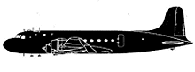
Incident Overview

Description
A Douglas C-54D aircraft was destroyed when it crashed on Taboga Island, Panama, killing all 23 on board. The aircraft operated a flight from West Palm Beach, Florida, to Panama City. The pilot had filed an IFR flight plan although he did not posses a valid instrument rating. Weather at Taboga Island was reported as a ceiling of approximately 750 feet above sea-level, with a visibility of 15 miles. The top 250 feet of Taboga was covered with cloud and visibility was 1/16 mile with light drizzle. While descending towards the destination airport, the airplane struck a mountain slope on Taboga Island. It is the opinion of the members of the Investigating Board that the pilot sighted Otoque Island and mistook it for Taboga and that he was in the vicinity of Otoque Island when he gave his estimated position of 15 miles southeast of the field. It is further believed that when the pilot called the tower and gave his estimated position as 5 miles south offield and at 1000 feet on instruments that he thought he was past Taboga Island, approaching Albrook Field, and that by dropping down a little he would be contact again. Actually the estimated distance of 10 miles traveled would place him over Taboga from Otoque.
Source of Information
http://www.canalzonestudygroup.com/Issue133.pdfhttp://www.canalzonestudygroup.com/Issue133.pdfPrimary Cause
Pilot error ? misidentification of Otoque Island.Pilot error ? misidentification of Otoque Island.Share on: