Incident Overview

Date: Friday 7 February 1997
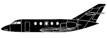
Aircraft Type: Dassault Falcon 20C
Owner/operator: Air Service
Registration Number: LV-WLH
Location: 36,4 km SW of Salta International Airport, SA (SLA) – ÿ Argentina
Phase of Flight: En route
Status: Destroyed, written off
Casualties: Fatalities: 4 / Occupants: 4
Component Affected: Falcon LV-WLH aircraft’s navigation system (specifically the GPS instrument).Falcon LV-WLH aircraft’s navigation system (specifically the GPS instrument).
Category: Accident
On October 26, 2023, a Falcon LV-WLH aircraft experienced a significant descent into a mountain during a cargo flight from C¢rdoba to Tucum n and Salta. The aircraft initially flew to FL180 over PONPI, 55 nautical miles south of Salta. Approximately two minutes later, the crew reported at 6500 feet on top of the clouds. Subsequently, the aircraft flew into the side of Cerr¢ Chivilme at an altitude of 6970 feet. The probable cause was a collision with a mountain during the descent prior to landing, resulting from an instrument approach procedure deviating from standard airport procedures with errors in distance and altitude. Contributing factors included the use of GPS as primary navigation, insufficient control over instruments and CRM, and a fictitious GPS point with the name ‘F-SAL’ which was confused with ‘SALT’ (Salta Airport) acronym.On October 26, 2023, a Falcon LV-WLH aircraft experienced a significant descent into a mountain during a cargo flight from C¢rdoba to Tucum n and Salta. The aircraft initially flew to FL180 over PONPI, 55 nautical miles south of Salta. Approximately two minutes later, the crew reported at 6500 feet on top of the clouds. Subsequently, the aircraft flew into the side of Cerr¢ Chivilme at an altitude of 6970 feet. The probable cause was a collision with a mountain during the descent prior to landing, resulting from an instrument approach procedure deviating from standard airport procedures with errors in distance and altitude. Contributing factors included the use of GPS as primary navigation, insufficient control over instruments and CRM, and a fictitious GPS point with the name ‘F-SAL’ which was confused with ‘SALT’ (Salta Airport) acronym.

Description

Falcon LV-WLH operated on a cargo flight from C¢rdoba (COR) to Tucum n (TUC) and Salta (SLA). The aircraft took off from Tucum n at 21:45. At 22:01 the crew reported at FL180 over reporting point PONPI, 55 nm Salta. Two minutes later the flight was cleared to descend to the cloud level. At 22:08 the crew reported at 6500ft on top of the clouds in visual conditions. Shortly afterward the airplane flew into the side of Cerr¢ Chivilme at an altitude of 6970 feet. CAUSA PROBABLE: “Colisi¢n con una monta¤a durante el descenso previo al aterrizaje, debido a efectuar un procedimiento de aproximaci¢n por instrumentos distintos al vigente en el aeropuerto de destino con error de distancias y alturas. Son factores concurrentes: – Usar el GPS como instrumento primario de navegaci¢n, cuando debe ser usado como instrumento suplementario o de referencia. – Falta de control sobre los instrumentos y procedimientos, por deficiente coordinaci¢n de cabina (CRM). – Colocaci¢n de un punto ficticio en el GPS con un nombre F-SAL que se confunde f cilmente con SAL, sigla del aeropuerto Salta.” PROBABLE CAUSE (translated from Spanish): Collision with a mountain during the descent prior to landing, while flying an instrument approach procedure other than the existing airport destination with errors in distances and heights. Contributing factors were: – Use of GPS as the primary instrument of navigation, when it should be used as a supplementary tool or reference. – Lack of control over the instruments and procedures, poor CRM. – Placement of a fictitious point in the GPS with the name “F-SAL” which is easily confused with “SALT”, the acronym of the Salta airport.

Primary Cause

Instrumental error and inadequate CRM during an instrument approach, leading to a deviation from standard airport procedures and resulting in a collision with a mountain.Instrumental error and inadequate CRM during an instrument approach, leading to a deviation from standard airport procedures and resulting in a collision with a mountain.

Share on:

Leave a Reply

Your email address will not be published. Required fields are marked *