Incident Overview

Date: Wednesday 14 October 2015
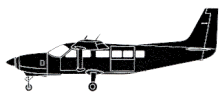
Aircraft Type: Cessna 208B Grand Caravan
Owner/operator: Microsurvey Aerogeof¡sica e Consultoria Cientifica
Registration Number: PR-MIC
Location: 3,6 km NW of Yumbillo – ÿ Colombia
Phase of Flight: En route
Status: Destroyed, written off
Casualties: Fatalities: 3 / Occupants: 3
Component Affected: Cessna 208B Grand Caravan aircraftCessna 208B Grand Caravan aircraft
Investigating Agency: AerocivilAerocivil
Category: Accident
A Cessna 208B Grand Caravan aircraft crashed during a VFR survey flight near Yumbulo in Colombia. All three occupants were killed. The aircraft, equipped with LIDAR, operated on a VFR flight out of Cali. The flight began at 11:39 and ended after seven minutes of climbing, impacting a wooded mountainside at an elevation of 6773 feet. The terrain presented a 60ø up slope and thick vegetation. Low cloud conditions prevailed. The probable cause was a crew decision to continue VFR operations in reduced visibility, coupled with inadequate operational risk assessment regarding the terrain and weather conditions.A Cessna 208B Grand Caravan aircraft crashed during a VFR survey flight near Yumbulo in Colombia. All three occupants were killed. The aircraft, equipped with LIDAR, operated on a VFR flight out of Cali. The flight began at 11:39 and ended after seven minutes of climbing, impacting a wooded mountainside at an elevation of 6773 feet. The terrain presented a 60ø up slope and thick vegetation. Low cloud conditions prevailed. The probable cause was a crew decision to continue VFR operations in reduced visibility, coupled with inadequate operational risk assessment regarding the terrain and weather conditions.

Description

A Cessna 208B Grand Caravan survey aircraft was destroyed when it impacted mountainous terrain near Yumbillo in Colombia. All three occupants were killed. The aircraft, fitted with LIDAR equipment, operated on a VFR survey flight out of Cali. It took off at 11:39 hours and made a climbing turn to the left. Seven minutes after takeoff the aircraft impacted a wooded mountainside, coming to rest at an elevation of 6773 feet. The accident terrain shows a 60ø up slope and thick vegetation. Weather conditions included low clouds. Probable cause: (translated from Spanish report) Execution of a VFR flight in reduced visibility weather conditions. Poor decision making by the crew in continuing VFR operation as they were in an environment of significantly reduced visibility. Inadequate operational risk assessment due to the lack of familiarity of the foreign crew with the topography and meteorological evolution of the sector.

Primary Cause

Crew decision to continue VFR operation in reduced visibility weather conditions and inadequate operational risk assessment.Crew decision to continue VFR operation in reduced visibility weather conditions and inadequate operational risk assessment.

Share on:

Leave a Reply

Your email address will not be published. Required fields are marked *