Incident Overview
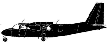
Date: Thursday 12 May 1977
Aircraft Type: Britten-Norman BN-2A-21 Islander
Owner/operator: Geofoto
Registration Number: PT-KUO
Location: near Curitiba, PR –
ÿ Brazil
Phase of Flight: En route
Status: Destroyed, written off
Casualties: Fatalities: 1 / Occupants: 1
Component Affected: AircraftAircraft
Category: Accident

A pilot reported a VFR flight over Paranagua at 18:43 UTC, receiving weather data indicating 20 km visibility, 4/8 broken formation at 1000m altitude, altimeter 1019.4mb, and a wind of 160/05. The pilot was cleared to proceed VFR and the last contact was made. The aircraft collided with a mountain at an elevation of 3000 feet, resulting in a collision.A pilot reported a VFR flight over Paranagua at 18:43 UTC, receiving weather data indicating 20 km visibility, 4/8 broken formation at 1000m altitude, altimeter 1019.4mb, and a wind of 160/05. The pilot was cleared to proceed VFR and the last contact was made. The aircraft collided with a mountain at an elevation of 3000 feet, resulting in a collision.
Description
The pilot reported over Paranagua at 18:43 UTC and was provided with the weather en route: visibility 20 km; 4/8 of broken formation at 1000 m covering the mountain peaks; altimeter 1019.4mb, wind 160/05. The pilot acknowledged and was cleared to proceed VFR. This was the last contact. Tthe aircraft collided with a mountain at an elevation of 3000 ft. Since no call was received from the aircraft it is believed that the collision resulted from an attempt to keep visual with insufficient visibility in a mountain area.
Primary Cause
Insufficient visibility in a mountainous terrain.Insufficient visibility in a mountainous terrain.Share on: