Incident Overview

Date: Wednesday 4 December 1974
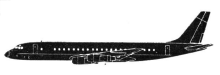
Aircraft Type: Douglas DC-8-55F
Owner/operator: Martinair Holland
Registration Number: PH-MBH
Location: Maskeliya – ÿ Sri Lanka
Phase of Flight: En route
Status: Destroyed, written off
Casualties: Fatalities: 191 / Occupants: 191
Component Affected: The aircraft itself (DC-8-55).The aircraft itself (DC-8-55).
Category: Accident
A Martinair DC-8-55 aircraft, MP138, crashed into the Anjimalai Mountain near Maskeliya, Sri Lanka, resulting in the deaths of all 191 occupants. The flight was initially cleared for a hadj flight to Jeddah, with a planned stop in Colombo, and then was diverted to a lower altitude due to radar warnings.A Martinair DC-8-55 aircraft, MP138, crashed into the Anjimalai Mountain near Maskeliya, Sri Lanka, resulting in the deaths of all 191 occupants. The flight was initially cleared for a hadj flight to Jeddah, with a planned stop in Colombo, and then was diverted to a lower altitude due to radar warnings.

Description

Martinair Holland flight MP138, a Douglas DC-8-55, impacted a mountain near Maskeliya, Sri Lanka, killing all 191 occupants. The aircraft departed Surabaya at 12:03 UTC for a hadj flight to Jeddah with a planned intermediate stop at Colombo. Around 16:30 UTC Colombo Control cleared the flight down from FL350 to FL150. At 16:38, when the flight was 50 nm from Colombo the air traffic controller cleared the flight further down to 5000 feet and to report reaching 8000 feet. At 16:44 Colombo Approach Control then cleared the flight down to 2000 feet and told them to expect a runway 04 approach. The crew were then to report overhead the KAT NDB or when the airfield was in sight. The crew continued their descent until the airplane crashed into the Anjimalai Mountain at an altitude of 4355 feet, about 40 nm East of Colombo. PROBABLE CAUSE: “Collision with rising terrain as the crew descended the aircraft below safe altitude owing to incorrect identification of their position vis-a-vis the airport. The investigation is of the opinion that this was the result of dependence on Doppler and Weather Radar Systems on board PH-MBH which left room for misinterpretation.”

Primary Cause

Incorrect identification of their position vis-a-vis the airport, potentially due to reliance on Doppler and Weather Radar Systems on board PH-MBH, leading to misinterpretation of the terrain and altitude.Incorrect identification of their position vis-a-vis the airport, potentially due to reliance on Doppler and Weather Radar Systems on board PH-MBH, leading to misinterpretation of the terrain and altitude.

Share on:

Leave a Reply

Your email address will not be published. Required fields are marked *