Incident Overview

Date: Saturday 10 August 1968
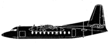
Aircraft Type: Fairchild FH-227B
Owner/operator: Piedmont Airlines
Registration Number: N712U
Location: Charleston-Kanawha County Airport, WV (CRW) – ÿ United States of America
Phase of Flight: Approach
Status: Destroyed, written off
Casualties: Fatalities: 35 / Occupants: 37
Component Affected: Aircraft Control System (specifically, altitude and orientation guidance)Aircraft Control System (specifically, altitude and orientation guidance)
Investigating Agency: NTSBNTSB
Category: Accident
A Piedmont flight 230 experienced a significant loss of altitude and orientation during an ILS localizer approach to Charleston-Kanawha County Airport (CRW) runway 23. The aircraft struck trees 360 feet from the runway threshold, subsequently losing altitude and trajectory, resulting in a nose-down attitude and subsequent impact with sloping terrain. The Fairchild aircraft followed up, coming to rest 6 feet beyond the threshold and 50 feet from the right edge of the runway.A Piedmont flight 230 experienced a significant loss of altitude and orientation during an ILS localizer approach to Charleston-Kanawha County Airport (CRW) runway 23. The aircraft struck trees 360 feet from the runway threshold, subsequently losing altitude and trajectory, resulting in a nose-down attitude and subsequent impact with sloping terrain. The Fairchild aircraft followed up, coming to rest 6 feet beyond the threshold and 50 feet from the right edge of the runway.

Description

Piedmont flight 230 was on an ILS localizer approach to Charleston-Kanawha County Airport (CRW) runway 23 when it struck trees 360 feet from the runway threshold. The aircraft continued and struck up sloping terrain (+30deg) 250 feet short in a 4-5deg nose down attitude, slightly left wing down. The Fairchild continued up the hill and on to the airport, coming to rest 6 feet beyond the threshold and 50 feet from the right edge of the runway. A layer of dense fog (about 150 feet thick) was obscuring the threshold and about half of the approach lights. Visual conditions existed outside the fog area. PROBABLE CAUSE: “An unrecognized loss of altitude orientation during the final portion of an approach into shallow, dense fog. The disorientation was caused by a rapid reduction in the ground guidance segment available to the pilot at a point beyond which a go-around could not be successfully effected.”

Primary Cause

An unrecognized loss of altitude orientation during the final portion of an approach into shallow, dense fog.An unrecognized loss of altitude orientation during the final portion of an approach into shallow, dense fog.

Share on:

Leave a Reply

Your email address will not be published. Required fields are marked *