Incident Overview

Date: Saturday 27 November 1965
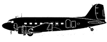
Aircraft Type: Douglas DC-3A
Owner/operator: Edde Airlines
Registration Number: N485
Location: 35 km S of Salt Lake City, UT – ÿ United States of America
Phase of Flight: Take off
Status: Destroyed, written off
Casualties: Fatalities: 13 / Occupants: 13
Component Affected: Aircraft structure (wing)Aircraft structure (wing)
Investigating Agency: NTSBNTSB
Category: Accident
On October 6, 2006, a DC-3 aircraft, N485, experienced a hard landing on Camp Williams Military Reserve due to pilot error during a flight from Salt Lake City to Albuquerque. The aircraft was cleared for takeoff with Provo weather, but the weather report for Provo was unavailable, prompting the pilot to request Salt Lake City weather. At 07:22, the flight was cleared for a runway 34 departure and special VFR after departure. The aircraft took off at 07:07 and was under Radar surveillance until 07:11. Witnesses reported a DC-3 passing overhead at low altitude (200-500 feet) and snow, with poor visibility. The aircraft then headed for sharply rising terrain of Camp Williams. The aircraft struck the 12-degree upslope of a hill at 5449 feet msl, 11 feet below the crest. The right wing separated, continuing 1202 feet over the hill, crashing at an elevation of 5275 feet msl (1608 m) against the 25-degree upslope of another hill.On October 6, 2006, a DC-3 aircraft, N485, experienced a hard landing on Camp Williams Military Reserve due to pilot error during a flight from Salt Lake City to Albuquerque. The aircraft was cleared for takeoff with Provo weather, but the weather report for Provo was unavailable, prompting the pilot to request Salt Lake City weather. At 07:22, the flight was cleared for a runway 34 departure and special VFR after departure. The aircraft took off at 07:07 and was under Radar surveillance until 07:11. Witnesses reported a DC-3 passing overhead at low altitude (200-500 feet) and snow, with poor visibility. The aircraft then headed for sharply rising terrain of Camp Williams. The aircraft struck the 12-degree upslope of a hill at 5449 feet msl, 11 feet below the crest. The right wing separated, continuing 1202 feet over the hill, crashing at an elevation of 5275 feet msl (1608 m) against the 25-degree upslope of another hill.

Description

N485 was prepared for a flight from Salt Lake City to Albuquerque with an intermediate stop in Provo. Prior to departure the crew requested Provo weather. Since this was not available the pilot then requested Salt Lake City weather information. The 06:00 weather report included 1600 feet overcast, visibility 5 miles in light snow showers. The forecast until 09:00 included sky obscured, 800 feet overcast and a one mile visibility. At 07:02 the flight was cleared for a runway 34 departure and special VFR after departure. The aircraft took off at 07:07 and was under Radar surveillance until 07:11. After that ground witnesses saw the DC-3 pass overhead at low altitude (200-500 feet). It was snowing at that time and visibility was poor. The aircraft headed for sharply rising terrain of Camp Williams Military Reserve. The DC-3 struck the 12-degree upslope of a hill at 5449 feet msl, 11 feet below the crest. The right wing separated the remainder of the aircraft continued 1202 feet over the hill, crashing at an elevation of 5275 feet msl (1608 m) against the 25-degree upslope of another hill. PROBABLE CAUSE: “Pilot attempted visual flight under unfavourable weather and terrain conditions, resulting in position disorientation and flight at an altitude too low to clear obstructing terrain. Judgement of the pilot in command in initiating a VFR flight operation under existing weather conditions and terrain environment.”

Primary Cause

Pilot attempted visual flight under unfavourable weather and terrain conditions, resulting in position disorientation and flight at an altitude too low to clear obstructing terrain.Pilot attempted visual flight under unfavourable weather and terrain conditions, resulting in position disorientation and flight at an altitude too low to clear obstructing terrain.

Share on:

Leave a Reply

Your email address will not be published. Required fields are marked *