Date: Saturday 19 February 1955
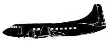
Aircraft Type: Martin 4-0-4
Owner/operator: Trans World Airlines – TWA
Registration Number: N40416
Location: 21 km NE of Albuquerque Municipal Airport, NM (ABQ) –
ÿ United States of America
Phase of Flight: En route
Status: Destroyed, written off
Casualties: Fatalities: 16 / Occupants: 16
Component Affected: Aircraft flight path and airways.Aircraft flight path and airways.
Investigating Agency: CABCAB