Incident Overview

Date: Wednesday 30 March 2022
Aircraft Type: Cessna 208 Caravan I
Owner/operator: Skydive Costa d’Argento, lsf Gladwings
Registration Number: D-FLIC
Location: S„ntis Mountain – ÿ Switzerland
Phase of Flight: En route
Status: Destroyed, written off
Casualties: Fatalities: 1 / Occupants: 1
Component Affected: Cessna 208 Caravan I (specifically, the aircraft’s flight control systems and navigation equipment).Cessna 208 Caravan I (specifically, the aircraft’s flight control systems and navigation equipment).
Investigating Agency: STSBSTSB
Category: Accident
On March 30, 2022, a Cessna 208 Caravan I, D-FLIC, crashed during a visual flight near the S„ntis massif in the Italian Alps. The pilot, identified as D-FLIC, was flying from Costa d?Argento Airfield to Siegerland Airport, Italy, and was operating under visual flight rules. The flight began visually, with the aircraft flying over the S„ntis massif at an altitude of approximately 8200 feet AMSL, following a pre-planned route. At 10:19 UTC, the pilot passed the Siegerland Airport waypoint, DEGES, and was instructed to remain under the Zurich terminal area (TMA). Approximately 10 minutes later, FIC Zurich communicated a change in airspace regulations, instructing the pilot to transition to flight level 130. The pilot responded by climbing to a rate of approximately 550 feet per minute. At 10:23 UTC, the aircraft collided with the northern flank of the Grehorn in the S„ntis massif, at an altitude of 6800 feet AMSL, in clouds. The accident was caused by continued visual flight under instrument meteorological conditions.On March 30, 2022, a Cessna 208 Caravan I, D-FLIC, crashed during a visual flight near the S„ntis massif in the Italian Alps. The pilot, identified as D-FLIC, was flying from Costa d?Argento Airfield to Siegerland Airport, Italy, and was operating under visual flight rules. The flight began visually, with the aircraft flying over the S„ntis massif at an altitude of approximately 8200 feet AMSL, following a pre-planned route. At 10:19 UTC, the pilot passed the Siegerland Airport waypoint, DEGES, and was instructed to remain under the Zurich terminal area (TMA). Approximately 10 minutes later, FIC Zurich communicated a change in airspace regulations, instructing the pilot to transition to flight level 130. The pilot responded by climbing to a rate of approximately 550 feet per minute. At 10:23 UTC, the aircraft collided with the northern flank of the Grehorn in the S„ntis massif, at an altitude of 6800 feet AMSL, in clouds. The accident was caused by continued visual flight under instrument meteorological conditions.

Description

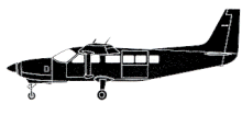
A Cessna 208 Caravan I, D-FLIC, was destroyed when it impacted the side of a mountain. The pilot suffered fatal injuries. On 29 March 2022, the day before the accident, the pilot was flying the Cessna 208, registered as D-FLIC, from Costa d?Argento Airfield in Italy to the Siegerland Airport (EDSG) for maintenance. He flew over the S„ntis massif under visual flight rules at an altitude of approximately 8200 ft AMSL and on the same route as on the day of the accident, namely on the direct connecting line between the waypoints PELAD and DEGES provided for flights under instrument flight rules. On 30 March 2022 at 09:02 UTC, the pilot took off in the Cessna 208 from EDSG on a visual flight to the airport Arezzo (LIQB) in Italy. At 10:19 UTC, he passed the waypoint DEGES at 5400 ft AMSL. He was in radio contact with FIC Zurich, which had instructed him to remain under the Zurich terminal area (TMA). This airspace has a lower limit of 7500 ft AMSL at DEGES. After passing DEGES, the pilot flew as planned in the direction of waypoint PELAD and at 10:19:31 UTC the FIC informed him that the maximum permitted altitude for visual flights without authorisation to enter controlled airspace was now flight level 130: “D-IC, report Bad Ragaz and now maximum flight level 130 possible”. The pilot replied with “Roger, will report [unreadable] can you confirm start um higher?” and wanted to make sure that he could now climb, which the FIC confirmed at 10:19:43 UTC with “D-IC affirm, you may continue climb up to maximum flight level 130”. The pilot then replied: “Roger, copied”. The rate of climb averaged around 550 ft/min. At 10:23 UTC, the aircraft collided with the northern flank of the Grehorn in the S„ntis massif at an altitude of 6800 ft AMSL on an unchanged flight path and flying in clouds. Causes The accident in which the aircraft collided with the terrain was due to the continuation of a visual flight under instrument meteorological conditions

Source of Information

https://www.tagblatt.ch/amp/ostschweiz/appenzellerland/ostschweiz-kleinflugzeug-im-appenzellerland-verschwunden-ld.2270230, https://flightaware.com/live/flight/DFLIC/history/20220330/0904Z/EDGS/L%2047.24582%209.31690https://www.tagblatt.ch/amp/ostschweiz/appenzellerland/ostschweiz-kleinflugzeug-im-appenzellerland-verschwunden-ld.2270230, https://flightaware.com/live/flight/DFLIC/history/20220330/0904Z/EDGS/L%2047.24582%209.31690

Primary Cause

Continued visual flight under instrument meteorological conditions (IMC) with a shift in airspace regulations.Continued visual flight under instrument meteorological conditions (IMC) with a shift in airspace regulations.

Share on:

Leave a Reply

Your email address will not be published. Required fields are marked *