Incident Overview

Date: Wednesday 22 May 2019
Aircraft Type: Cessna S550 Citation S/II
Owner/operator: private
Registration Number: N311G
Location: near Indianapolis Regional Airport, IN (KMQJ) – ÿ United States of America
Phase of Flight: Initial climb
Status: Destroyed, written off
Casualties: Fatalities: 2 / Occupants: 2
Component Affected: Aircraft EngineAircraft Engine
Investigating Agency: NTSBNTSB
Category: Accident
On October 26, 2023, an instrument flight rules (IFR) Cessna S550 Citation airplane, N311G, impacted a flooded corn field approximately one mile northeast of Indianapolis Regional Airport (MQJ), Indiana. The pilot and sole passenger were fatally injured, and the aircraft was destroyed. Radar data indicated the aircraft departed from runway 7 at MQJ and began a left turn towards ATC’s assigned heading of 320ø shortly after departure. The airplane descended to approximately 1,400 feet MSL, then disappeared from radar. A witness reported seeing the airplane in a 90-degree left bank with the nose parallel to the horizon shortly after departure, and observed a nose lower slightly before rising to a level attitude. The nose of the aircraft then lowered, resulting in impact with the ground. The wreckage covered an area of approximately 270 feet long and 103 feet wide, with initial ground scar aligned at 327ø magnetic heading. The wreckage and debris field were characterized by significant fragmentation. The engines separated and were located approximately 197 feet from the impact point, roughly aligned with the ground scar. A post-impact fire incinerated approximately 80% of the airplane. The probable cause was identified as the pilot’s failure to fully advance the power levers during takeoff and initial climb, leading to insufficient airspeed and a stall, resulting in aerodynamic instability and a loss of control.On October 26, 2023, an instrument flight rules (IFR) Cessna S550 Citation airplane, N311G, impacted a flooded corn field approximately one mile northeast of Indianapolis Regional Airport (MQJ), Indiana. The pilot and sole passenger were fatally injured, and the aircraft was destroyed. Radar data indicated the aircraft departed from runway 7 at MQJ and began a left turn towards ATC’s assigned heading of 320ø shortly after departure. The airplane descended to approximately 1,400 feet MSL, then disappeared from radar. A witness reported seeing the airplane in a 90-degree left bank with the nose parallel to the horizon shortly after departure, and observed a nose lower slightly before rising to a level attitude. The nose of the aircraft then lowered, resulting in impact with the ground. The wreckage covered an area of approximately 270 feet long and 103 feet wide, with initial ground scar aligned at 327ø magnetic heading. The wreckage and debris field were characterized by significant fragmentation. The engines separated and were located approximately 197 feet from the impact point, roughly aligned with the ground scar. A post-impact fire incinerated approximately 80% of the airplane. The probable cause was identified as the pilot’s failure to fully advance the power levers during takeoff and initial climb, leading to insufficient airspeed and a stall, resulting in aerodynamic instability and a loss of control.

Description

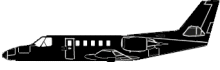
The Cessna S550 Citation airplane, N311G, impacted a flooded corn field about half a mile northeast of Indianapolis Regional Airport (MQJ), Indiana. The airplane was owned and operated by the pilot as an instrument flight rules (IFR) flight when the accident occurred. The pilot and the sole passenger were fatally injured and the airplane was destroyed. The flight departed MQJ about 1243 destined for Minden-Tahoe Airport (MEV), Nevada. Radar data depicted the airplane departing from runway 7 at MQJ. Shortly after departure, the airplane began a left turn towards an air traffic control (ATC) assigned heading of 320ø. After reaching an altitude of about 1,400 ft MSL, the airplane descended until it disappeared from the radar. A witness on the ground at MQJ reported seeing the airplane in an estimated 90ø left bank with the nose parallel to the horizon shortly after departure. He observed the airplane’s nose lower slightly before rising again to a level attitude. At no point did he observe the nose of the airplane rise above the horizon. The nose of the airplane again lowered and the airplane impacted the ground. The airplane impacted a flooded cornfield and exhibited significant fragmentation. The wreckage and debris field covered an area of about 270 ft long and 103 ft wide. The initial ground scar was aligned on about a 327ø magnetic heading (MH). The nose of the airplane came to rest on a 268ø MH and the tail came to rest on a 182ø MH. Both engines separated from the airplane and were located about 197 ft from the point of initial impact, roughly aligned with the ground scar. A post-impact fire incinerated about 80% of the airplane. Probable cause: “The pilot’s failure to fully advance the power levers during the takeoff and initial climb, which led to his failure to maintain sufficient airspeed and resulted in the exceedance of the airplane’s critical angle of attack and a subsequent aerodynamic stall.”

Source of Information

https://www.theindychannel.com/news/local-news/two-killed-in-plane-crash-near-indianapolis-regional-airport, https://eu.indystar.com/story/news/crime/2019/05/22/plane-crash-indiana-mount-comfort-indianapolis-regional-airport/3768463002/, https://edition.cnn.com/2019/05/22/us/indiana-plane-crash/index.htmlhttps://www.theindychannel.com/news/local-news/two-killed-in-plane-crash-near-indianapolis-regional-airport, https://eu.indystar.com/story/news/crime/2019/05/22/plane-crash-indiana-mount-comfort-indianapolis-regional-airport/3768463002/, https://edition.cnn.com/2019/05/22/us/indiana-plane-crash/index.html

Primary Cause

Pilot’s failure to fully advance the power levers during takeoff and initial climb, leading to insufficient airspeed and a stall.Pilot’s failure to fully advance the power levers during takeoff and initial climb, leading to insufficient airspeed and a stall.

Share on:

Leave a Reply

Your email address will not be published. Required fields are marked *