Incident Overview

Date: Friday 8 June 1984
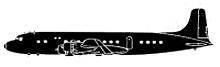
Aircraft Type: Douglas C-118B
Owner/operator: Northern Air Cargo
Registration Number: N4206L
Location: Deadhorse, AK – ÿ United States of America
Phase of Flight: Approach
Status: Substantial
Casualties: Fatalities: 0 / Occupants: 3
Component Affected: AntennaAntenna
Investigating Agency: NTSBNTSB
Category: Accident
An ACFT struck a non-directional radio beacon tower while on an ILS DME approach to the Kuparak Oil Field Airport. Investigation revealed an undefined 200-foot sky obscured condition and 1 1/4-mile visibility loss. Both the Captain and Co-Pilot stated they could see the other end of the runway.An ACFT struck a non-directional radio beacon tower while on an ILS DME approach to the Kuparak Oil Field Airport. Investigation revealed an undefined 200-foot sky obscured condition and 1 1/4-mile visibility loss. Both the Captain and Co-Pilot stated they could see the other end of the runway.

Description

THE ACFT STRUCK A NON-DIRECTIONAL RADIO BEACON TOWER WHILE ON AN ILS DME RWY 05 INSTRUMENT APPROACH TO THE KUPARAK OIL FIELD AIRPORT. INVESTIGATION REVEALED THAT WX ISSUED TO THE ACFT INCLUDED AN INDEFINATE 200 FT SKY OBSCURED CONDITION & VISIBILITY OF 1 1/4 MILES. BOTH THE CAPTAIN & CO-PLT STATED THAT THEY COULD SEE THE OTHER END OF THE RWY. THE DECISION HEIGHT FOR THE APPROACH IS 316 FT MSL; THE ANTENNA HEIGHT WAS 35 FT, AT THIS POINT THE ACFT SHOULD BE 250 FT ABOVE THE GROUND AND OVER THE NON-DIRECTIONAL BEACON TOWER. INVESTIGATION DID REVEAL THAT THE TOWER USED TO BE LOCATED 2800 FT OFF THE APPROACH END OF RWY 05, BUT WAS MOVED TO 1775 FT FROM THE APPROACH END OF RWY 05. EXISTING APPROACH PLATES DID NOT DISPLAY THE NEW LOCATION OF THE ANTENNA OR THE FACT THAT THE ANTENNA WAS ONE FT HIGHER THAN THE MAXIMUM AUTHORIZED BY THE FCC. Probable Cause:

Primary Cause

Incorrect antenna height and tower location.Incorrect antenna height and tower location.

Share on:

Leave a Reply

Your email address will not be published. Required fields are marked *