Incident Overview

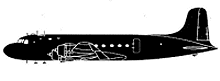
Date: Thursday 12 December 1963
Aircraft Type: Douglas C-54A-15-DC (DC-4)
Owner/operator: Trans Mediterranean Airways – TMA
Registration Number: OD-AEB
Location: 93 km W of Ghazni – ÿ Afghanistan
Phase of Flight: En route
Status: Destroyed, written off
Casualties: Fatalities: 3 / Occupants: 3
Component Affected: Aircraft Navigation SystemAircraft Navigation System
Category: Accident
On August 12, 1964, a DC-4 aircraft diverted from Beirut to Kabul experienced a navigational error leading to a route change to Lahore. The aircraft was lost after being sighted at an altitude of 13940 feet in the Koh-i-Safid Mountains, approximately 50 nautical miles west of Ghazni and 42 nautical miles from the approved air route. The wreckage was discovered after snowmelt, at an elevation of 13940 feet.On August 12, 1964, a DC-4 aircraft diverted from Beirut to Kabul experienced a navigational error leading to a route change to Lahore. The aircraft was lost after being sighted at an altitude of 13940 feet in the Koh-i-Safid Mountains, approximately 50 nautical miles west of Ghazni and 42 nautical miles from the approved air route. The wreckage was discovered after snowmelt, at an elevation of 13940 feet.

Description

The DC-4 was on a cargo flight from Beirut to Kabul via Kuwait and took off from Kuwait at 02:56 GMT with an ETA at Kabul of 10:10. At 09:58 the crew reported over Kabul and requested weather information. Weather conditions didn’t permit a landing at Kabul, so the crew chose to divert to Lahore. The route to Lahore was via Ghazni, Kandahar and Zahedan. It would maintain FL150 to Ghazni, FL130 to Kandahar and FL110 to Zahedan. After being cleared to route frequency by Kabul tower, nothing more was heard from the flight. The wreckage was first sighted on 12 August 1964 after the snow had melted, at an elevation of 13940 feet amsl (4250 m) in the Koh-i-Safid Mountains, 50nm W of Ghazni and 42nm from the approved air route. PROBABLE CAUSE: “A wrong estimation of the wind speed and direction resulted in a navigation error which brought the aircraft 42nm from the approved air route. Possible contributing factors were: lack of weather forecast prior to takeoff, personal worries, fatigue and lack of oxygen, inadequate charts and maps.”

Source of Information

https://digitalcommons.unomaha.edu/cgi/viewcontent.cgi?article=1691&context=kabultimeshttps://digitalcommons.unomaha.edu/cgi/viewcontent.cgi?article=1691&context=kabultimes

Primary Cause

A wrong estimation of the wind speed and direction resulted in a navigation error.A wrong estimation of the wind speed and direction resulted in a navigation error.

Share on:

Leave a Reply

Your email address will not be published. Required fields are marked *